The collapse of a base jumping platform on a cliff before launch has put geological assessment protocols under scrutiny. The incident, which could have been a tragedy, is being investigated using advanced 3D modeling tools. The post-mortem analysis, conducted with CloudCompare, Pix4D, and Bentley OpenRoads, determined that the rock's porosity was underestimated in the design, compromising the integrity of the chemical anchors. This case becomes a benchmark for structural catastrophe simulation.
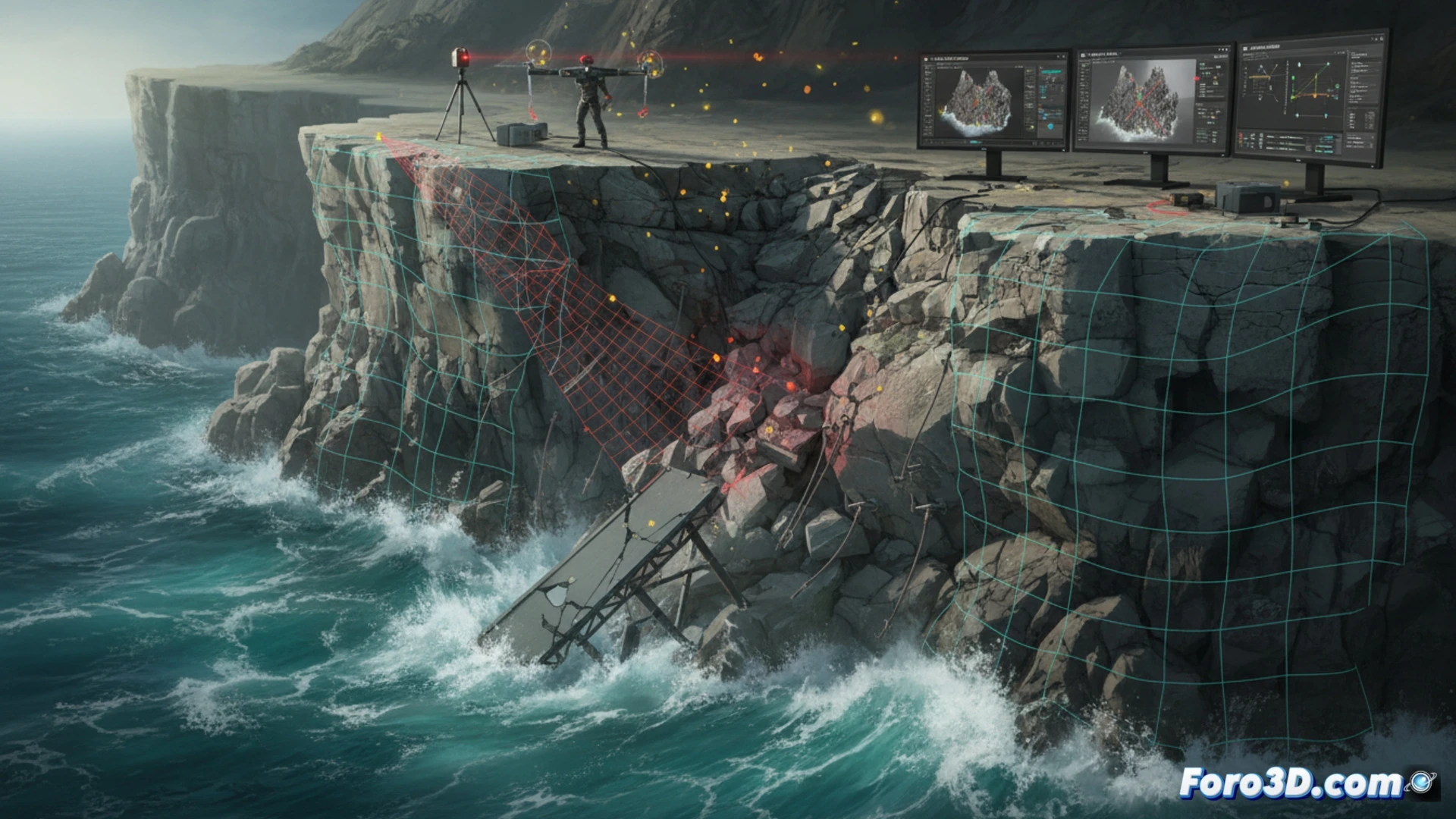
Technical workflow: From LiDAR scanning to anchor inspection 🛠️
The forensic team initiated the process with a LiDAR scan of the cliff to generate a high-resolution point cloud in CloudCompare, allowing visualization of the macrogeology and existing fractures. Subsequently, Pix4D was used to process the photogrammetry of the anchors, creating a detailed 3D model of the drill holes and resins. The key to the analysis lay in importing this data into Bentley OpenRoads. By overlaying the georeferenced point cloud with the photogrammetric model of the anchors, a critical discrepancy was detected: the rock-anchor interface simulation did not account for the actual porosity of the substrate. The software revealed that the chemical resin distribution failed to properly adhere to the internal cavities of the rock, an error that the previous 3D model had overlooked by assuming homogeneous density.
Lessons for prevention: Porosity as a critical variable ⚠️
The collapse demonstrates that the beauty of the initial 3D model can conceal fatal flaws. The integration of CloudCompare for structural analysis and Pix4D for microscopic inspection, unified in Bentley OpenRoads, not only reconstructed the failure but also validated a new protocol. Now, any temporary structure on rock must include a porosity map derived from these combined data. Catastrophe is avoided not with prettier models, but with simulations that integrate the heterogeneity of the terrain. This case sets an indelible technical precedent for risk engineering.
Could the combined analysis of LiDAR point clouds and high-resolution photogrammetric models predict structural fatigue in rock formations used for base jumping before a catastrophic collapse occurs?
(PS: Simulating catastrophes is fun until the computer crashes and you are the catastrophe.)