When Digital Simulation Can Save Real Lives
The recent flooding tragedies in Mexico raise a crucial question: could available simulation technology have predicted and mitigated these disasters? The answer is a resounding yes. The combination of GIS software for precise topographic modeling with fluid simulation tools like Houdini and Blender can create extremely accurate predictive models of water behavior in urban environments. These technologies, routinely used in visual effects for cinema, have direct applications in urban planning and emergency management.
What makes this approach particularly valuable is its ability to simulate complex scenarios that traditional civil engineering methods cannot fully capture. While conventional hydraulic calculations work with simplifications, computational fluid dynamics (CFD) simulations can model chaotic interactions between water, infrastructure, and topography with a level of detail that reveals critical points invisible to traditional analysis.
Water follows the laws of physics, not bureaucracy, and our software can calculate those laws before tragedy strikes
Creating the Topographic Model with GIS
The process begins with Geographic Information Systems (GIS) like QGIS, ArcGIS, or open-source tools that can import LIDAR data, contour lines, and digital elevation models. These systems allow creating precise 3D terrain models with sub-metric resolution, capturing not only natural topography but also critical urban elements like streets, buildings, sewers, and natural waterways. Precise georeferencing is essential to ensure simulations correspond to physical reality.
Modern LIDAR data can capture terrain with 10-30 cm precision, revealing micro-depressions and imperceptible slopes that determine exactly where water will accumulate. This information is exported to compatible formats like OBJ, FBX, or point cloud formats that can be directly imported into Blender or Houdini for the simulation phase.
- Importing LIDAR data and digital elevation models
- Precise 3D modeling of urban infrastructure
- Georeferencing for real-world correspondence
- Exporting to 3D formats compatible with simulation software
Preparing the Model for Simulation in Houdini
Once the GIS model is imported into Houdini, it is converted into an optimized simulation mesh for fluid calculations. The process involves cleaning and repairing the geometry, defining surface materials (asphalt, soil, grass, concrete) with their respective friction and permeability coefficients, and setting boundary conditions like water inlets, outlets, and absorption areas. Houdini is particularly powerful for this type of simulation thanks to its VDB-based dynamics system that efficiently handles large volumes.
The fluid solver setup is where the scientific magic happens. Parameters like viscosity, surface tension, and turbulence are adjusted to match real rainwater behavior. Houdini's FLIP particle system is ideal for this type of simulation because it captures natural water behavior with fewer numerical artifacts than other methods, producing results that match real-world observations remarkably well.
In Houdini, every virtual raindrop follows the same physical laws that could drown entire neighborhoods
- Conversion to optimized simulation mesh
- Definition of surface materials with realistic properties
- FLIP solver setup for natural behavior
- Establishing boundary conditions and water sources
Simulation of Extreme Rainfall Scenarios
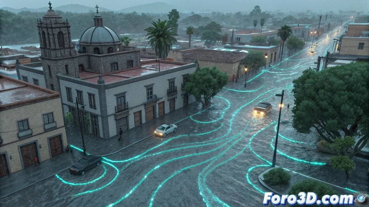
The true predictive power comes from the ability to simulate different precipitation scenarios. We can model from moderate rains of 50 mm/hour to extreme events of 200+ mm/hour, exactly the types of storms that have caused recent tragedies in Mexico. Each scenario reveals different accumulation and flow patterns, identifying not only obvious flooding points but also secondary flow paths and domino effects that traditional methods overlook.
Simulations can incorporate existing drainage infrastructure, modeling how sewers saturate and overflow, and how water seeks alternative paths when the formal system collapses. This is crucial because many urban floods are not caused by lack of drainage, but by overload and blockage of existing systems.
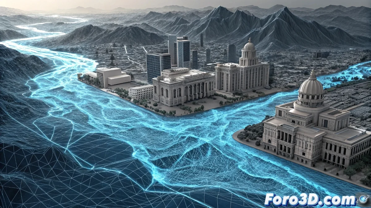
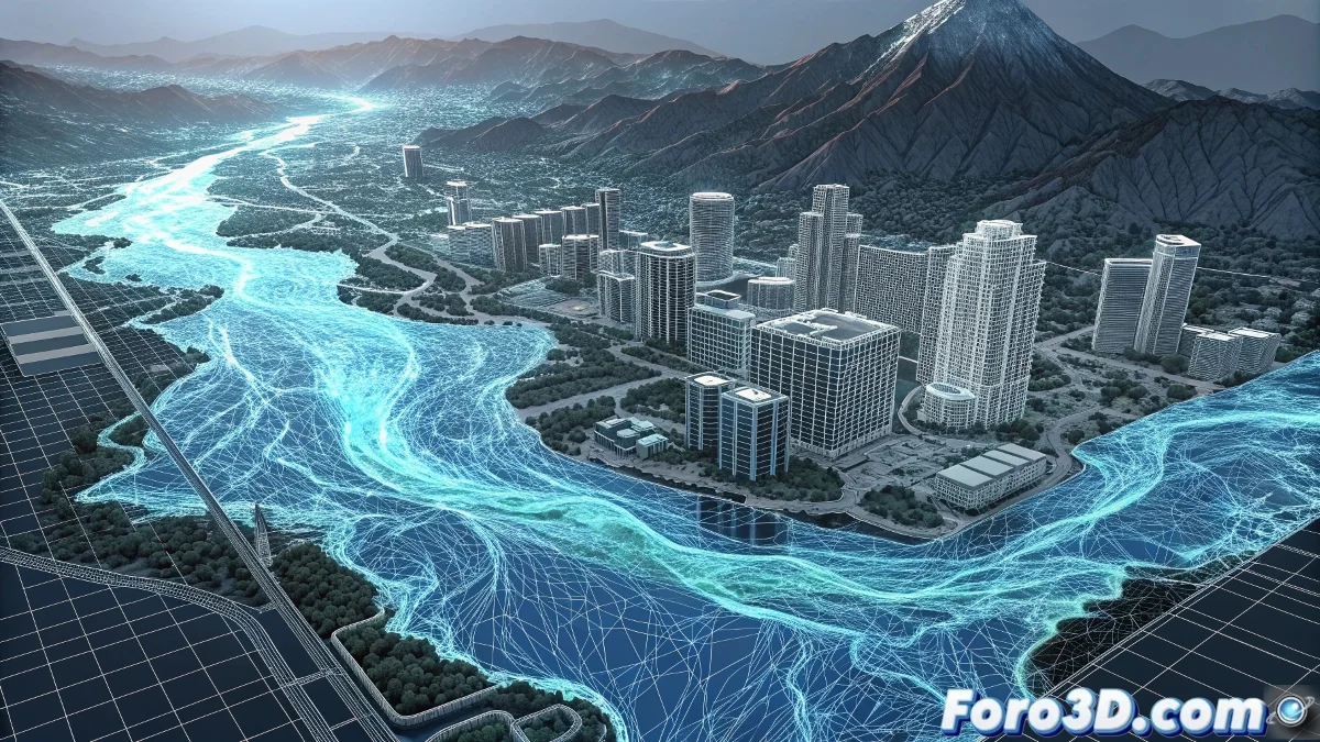
Results Analysis and Critical Points Identification
Once simulations are complete, Houdini and Blender offer advanced analysis tools to quantify and visualize results. We can generate water depth maps, flow velocity visualizations, flood timing animations, and accumulated volume calculations by area. This data can be exported back to GIS to create detailed risk maps with quantitative information instead of qualitative estimates.
Urban watershed analysis reveals how small terrain modifications, a slightly higher curb, a sunken garden, can divert critical flows and prevent flooding. This granularity is impossible to obtain with traditional methods and can identify low-cost, high-impact solutions.
- Water depth and velocity maps
- Temporal animations of flood progression
- Volume calculations by affected area
- Identification of interventions with low cost and high impact
Integration with Blender for Visualization and Communication
Blender perfectly complements this pipeline by providing high-quality visualization and rendering capabilities to communicate findings to non-experts. While Houdini specializes in raw simulation, Blender can create understandable and impactful visualizations that show how water would affect specific buildings, streets, and critical infrastructure. The Eevee engine integration allows real-time rendering of complex scenarios, facilitating interactive presentations to authorities and communities.
Blender's compositing capabilities allow overlaying simulation data on real satellite images, creating visualizations that immediately connect abstract analysis with the familiar reality of residents. This is invaluable for communicating risk and justifying prevention investments.
A clear visualization can convince more effectively than a thousand pages of technical report
Practical Application in the Mexican Context
In the specific case of torrential rains in Mexico, this approach could have identified weeks or months in advance the exact points where the worst floods occurred. The unique topographic features of Mexican cities, combining mountainous areas with dense urbanization, natural waterways turned into streets, are particularly suited for this type of analysis. Simulation could have revealed how water from slopes converges at specific valley points, overloading drainage systems designed for lesser capacities.
For marginalized communities often located in high-risk areas, these tools could provide incontrovertible evidence for preventive relocations or specific protective infrastructure design. The cost of implementing this system is minimal compared to human and economic losses from a single major flood.
Implementation and Technical Challenges
Implementing this system at the municipal scale faces challenges, but they are completely surmountable with current technology. It requires access to high-resolution LIDAR data (available for many Mexican cities), adequate computing hardware (a workstation with a modern GPU can simulate significant urban areas), and trained personnel in GIS and simulation. Detailed simulation computation time ranges from hours for neighborhood models to days for entire cities, but the results more than justify the investment.
The biggest obstacles are not technical but organizational: coordination between government agencies, budget allocation for prevention rather than just response, and political will to act based on scientific evidence even when it contradicts established interests.
- High-resolution LIDAR data as essential base
- Computing hardware accessible to local governments
- Specialized training in GIS and simulation
- Overcoming organizational barriers more than technical ones
The Cost of Inaction
As Mexico and other Latin American countries continue facing extreme weather events with increasing frequency, implementing these technologies ceases to be an option and becomes a ethical and economic obligation. The cost of a complete predictive simulation system is equivalent to the value of a few homes lost in a single flood, not to mention the incalculable value of human lives.
The tools exist, the knowledge exists, the data exists. What has been lacking is the will to systematically integrate them into urban planning and emergency management. Each tragedy like the recent rains in Mexico reminds us that science-based prevention is not a luxury, it is a fundamental necessity of modern governance.
The question is not whether we can afford to implement these systems, but whether we can afford not to implement them 🌧️