Recreating the Lost Towns of the St. Lawrence River in Houdini: Submerged Memory
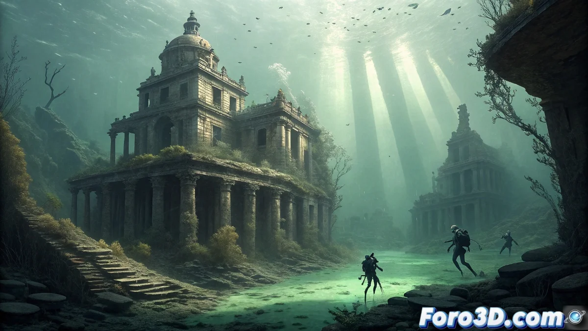
The Lost Towns of the St. Lawrence River in Canada represent one of the most moving episodes of 20th-century engineering, where a series of historic communities were sacrificed and intentionally flooded in 1958 to create the St. Lawrence Seaway and a massive hydroelectric project. These towns, including communities like Aultsville, Dickinson's Landing, and Moulinette, now lie preserved as underwater ruins on the riverbed, forming an aquatic cemetery of entire communities whose structures remain frozen in time, occasionally visited by divers exploring this silent testament to human progress. 🌊
Setting the Historical and Topographical Context
Start by researching the original topography of the towns before the flooding. The communities were located along the St. Lawrence River shoreline and featured a combination of residential, commercial, and industrial architecture typical of 1950s Ontario.
Base Scene Preparation in Houdini:- Create terrain geometry using Heightfield nodes with historical topographic data
- Establish real scale based on historical maps of the flooded towns
- Set up metric units for precision in water simulations
"These towns did not die naturally; they were deliberately sacrificed for progress, creating a unique underwater time capsule in the world" - Canadian preservation historian
Procedural Modeling of Urban Structures
Use Houdini's procedural power to recreate the characteristic urban layout of these towns. Develop systems that automatically generate streets, lots, and buildings based on documented historical patterns.
Procedural Modeling Techniques:- Use node-based modeling to create 1950s architectural variations
- Implement L-systems for street generation and lot distribution
- Apply Copy Stamp to instance buildings with unique variations
Controlled Flooding Simulation
Create a realistic fluid simulation that captures the gradual flooding process that occurred between 1955-1958. The St. Lawrence River water was dammed and released controllably to systematically submerge the towns.
FLIP Simulation Setup in Houdini:- FLIP Container with appropriate resolution to capture flooding details
- Emission source simulating the progressive rise of the river level
- Collision objects for all structures interacting with the water
Sedimentation and Temporal Deterioration Effects
Simulate the sedimentation and deterioration process that has occurred over more than six decades underwater. River sediments have deposited on the structures, while water action has eroded some elements.
Effects Systems for the Passage of Time:- Particle systems for simulating sediments accumulating on structures
- VDB from Particles to convert particles into solid sediment geometry
- Procedural erosion using Heightfield erosion nodes on submerged structures
Final Composition and Emotional Narrative
Develop visual compositions that convey the emotional weight of these lost towns. Use camera angles that show the human scale of the tragedy, such as submerged streets with streetlights still standing or houses with windows broken by water pressure. The underwater lighting must be melancholic, with rays of light filtering through the murky river water, creating an atmosphere that honors the memory of the communities that once thrived on these now-submerged lands. 🏘️