3D Technology as a Forensic Weapon Against Illegal Deforestation
In the battle for ecosystem conservation, three-dimensional modeling has emerged as a precision forensic tool. An innovative workflow, or pipeline, is being deployed by environmental protection agencies to combat illegal logging, transforming raw data into irrefutable legal evidence. 🌳
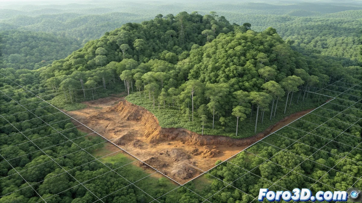
Capture and Reconstruction of the Forest Crime Scene
The process begins with data acquisition from the air. Airplanes or drones equipped with LiDAR sensors fly over protected areas, emitting millions of laser pulses. The return of these signals generates a massive and high-precision point cloud, which captures the topography and vertical structure of the forest with millimeter detail. This dataset is processed to build a digital twin of the territory: a metrically exact and photorealistic 3D model that documents the height, density, and vegetation cover at a specific moment.
Key Components of the Capture Phase:- LiDAR Acquisition: Airborne laser scanning to obtain the 3D geometry of the terrain and vegetation.
- Point Cloud Generation: Spatial dataset representing each laser return as an XYZ coordinate.
- 3D Modeling: Processing the point cloud to create a volumetric and textured representation of the forest.
The technology allows the forest, a silent witness, to speak through its own data transformed into three-dimensional models.
Forensic Analysis: Temporal Comparison and Damage Volumetrics
The core of this method is temporal comparative analysis. The current 3D model is automatically compared with historical reference models stored in geospatial databases. Using specialized software, point cloud difference operations are performed, accurately identifying areas where forest cover has been removed. Beyond delineating the area, the analysis enables loss volumetrics. By processing LiDAR data, it is possible to estimate the disappeared biomass and calculate the volume of extracted wood, a vital metric for quantifying the ecological impact and the economic value of the stolen resource.
Analysis Tools and Results:- Point Cloud Comparison: Software like CloudCompare to detect millimeter changes between two scans on different dates.
- Biomass and Volume Calculation: Applications like FUSION/LDV analyze forest structure to estimate lost wood.
- Georeferencing: Integration of findings into Geographic Information Systems (GIS) like QGIS or ArcGIS Pro for spatial contextualization.
From Intelligence to Action and Visual Evidence
The georeferenced information is transformed into an operational intelligence map, enabling authorities to plan interventions with exact coordinates of logging clearings, access roads, and illegal settlements. To powerfully communicate findings to prosecutors, judges, or the public, forensic 3D models are brought into advanced visualization environments. By importing them into engines like Unreal Engine, immersive virtual tours and impactful visualizations are created that intuitively and indisputably show the landscape transformation. This ability to "make the forest speak" provides the evidence that nature cannot present by itself in court, closing the cycle from data capture to conviction. ⚖️